

Table of Contents
Chapter 1 Concept Decoding: Global Paradigm of Metropolitan Areas and Hong Kong Practice
1.1 A model for the development of a global metropolitan area
From the "Three-State Plan" of the New York metropolitan area to the wide-area administration of the Tokyo metropolitan area, international experience shows that the development of mega-urban agglomerations needs to transcend administrative boundaries. Under the cooperation framework of 11 cities in the Guangdong-Hong Kong-Macao Greater Bay Area,Northern Metropolitan AreaIt essentially constitutes a "special zone in the Bay Area", and its planning draws on the experience of industrial-city integration of Singapore's Jurong East Smart Eco-City and Shenzhen's Qianhai Shenzhen-Hong Kong Modern Service Industry Cooperation Zone.
1.2 Paradigm shift in Hong Kong’s spatial strategy
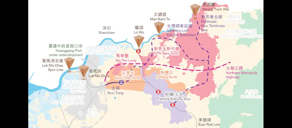
對比過往新市鎮開發的「臥城」模式,北部都會區採用「15分鐘生活圈」的TOD(Transit-Oriented Development)理念。規劃文件顯示將整合邊境禁區釋放的3,000公頃土地,相當於港島北岸建成區的1.8倍,標誌著香港從「維港都會」向「雙都會中心」的空間革命。
1.3 Innovation in the legal framework
The draft of the "Northern Metropolitan Area Development Regulations" pioneered a "special development mechanism" that allows for a fast-track approval process that integrates planning, land administration, and environmental reviews in specific areas. This move breaks through the current statutory procedure of the "Town Planning Regulations" which takes seven years, and has triggered a debate in the legal community about procedural justice.
Chapter 2 Historical Latitudes and Longitudes: From a Forbidden Borderland to a National Gateway
2.1 The evolution of the military restricted area over the past century
The "Frontier Restricted Area" defined in the "Convention for the Extension of Hong Kong Territory" in 1898 became a military buffer zone about half a mile wide after the Hong Kong British government promulgated the "Closed Frontier Areas Order" in 1951. In 2012, the first phase was reduced to 400 meters, and after its full opening in 2016, 2,800 hectares of land were released, laying the spatial foundation for the metropolitan area.
2.2 Thirty Years of Integration between Shenzhen and Hong Kong
– In 1997, the average daily customs clearance volume at Lok Ma Chau Port was less than 10,000 people
– 2007 “Shenzhen-Hong Kong Innovation Circle” agreement signed
– The implementation of “Co-location, Two Checkpoints” at the West Kowloon Station of the Guangzhou-Shenzhen-Hong Kong Express Rail Link in 2017
– The 2021 Northern Metropolitan Area Development Strategy proposes the construction of “two cities and three circles”
2.3 Spatial projection of national strategy
The "14th Five-Year Plan" clearly defines Hong Kong's positioning as one of the "eight centers", and the northern metropolitan area will actually carry the functions of an international innovation and technology center and a cultural and artistic exchange center. Its spatial layout echoes the aggregation effect of the "Shenzhen-Hong Kong" pole in the "Outline Development Plan for the Guangdong-Hong Kong-Macao Greater Bay Area".

Chapter 3 Spatial Deconstruction: Strategic Configuration of Six Functional Sections
3.1 Chuangke Central Axis Belt
The Hong Kong-Shenzhen Innovation and Technology Park, which is under planning and construction, will cover an area of 87 hectares and will form an "one river, two banks" innovation corridor with the Shenzhen Science and Technology Innovation Park. Government documents revealed that 10 national key laboratories will be introduced with the goal of gathering 500 high-tech companies.
3.2 Port Economic Circle
San Tin Science Park is adjacent to the Lok Ma Chau Port, and the planned eastern extension of the MTR North Link Line will enable direct access to Shenzhen Futian Station in 8 minutes. The Economist Intelligence Unit predicts that the port economic zone can create 120,000 jobs.
3.3 Ecological Conservation System
The 2,000-hectare wetland conservation park will adopt a "development rights transfer" mechanism, allowing developers to balance construction needs by purchasing conservation plot ratios. Environmental groups question whether the system could lead to fragmented conservation.
3.4 Cultural Hub Cluster
The proposed cultural and museum facilities include:
– Branch of the Palace Museum
– National Intangible Cultural Heritage Exhibition Center
– International Performing Arts Complex
The cultural community is concerned about the positioning and division of labor between the West Kowloon Cultural District and the Northern Metropolitan District.
3.5 Xintian Transportation Hub
The planned Hong Kong-Shenzhen Western Railway (from Hung Shui Kiu to Qianhai) will enable 15-minute rail commuting and, together with the Northern Loop Line branch line, form a "three horizontal and three vertical" rail network. The Civil Engineering Department estimates that 22 kilometers of new underground tunnels will be needed.
3.6 Livable living area
The smart community is designed based on the “vertical city” concept, with a planned population density of 3,000 people per hectare. The "community facilities complex" model will be piloted to integrate schools, medical care and commercial facilities into a single building complex.
Chapter 4 Economic Transformation: Spatial Reorganization of Hong Kong’s Industrial Structure
4.1 Innovation and Technology Industry Cluster
Benchmarking against Shenzhen Nanshan Science and Technology Park, we plan to build a "microelectronics R&D pilot base" and a "biomedical accelerator." The Innovation and Technology Commission plans to launch a "BOT" model for scientific research land, allowing companies to bid for land with their technology.
4.2 Professional Service Upgrade
The cross-border legal services park will pilot the "Guangdong-Hong Kong-Macao Joint Law Firm Version 2.0", allowing lawyers from the three places to jointly establish partnership firms. The accounting industry is preparing to establish the "Greater Bay Area Accounting Standards Coordination Centre".
4.3 New model of port economy
The new Huanggang Port, which implements the policy of "cooperative inspection and one-time release", will be equipped with a duty-free commercial city, drawing on the "front shop and back warehouse" model of the Dubai Airport Free Zone. Economists predict that the annual trade volume of the port economic zone can reach HK$600 billion.
4.4 Land Finance Transformation
The Development Bureau is studying the "infrastructure bond" financing option and plans to issue 30-year bonds to raise HK$200 billion. At the same time, it is proposed to introduce a "land value-added recovery" mechanism to levy 40% of value-added income on private projects.
No.Chapter 5 Social Impact: Population Migration and Community Reconstruction
5.1 Prediction of new immigration waves
Government population estimates show the northern metropolitan area will be home to 2.5 million people by 2040, including 600,000 cross-border workers. The sociological community is concerned about the impact of the "dual-city life" model on family structure.
5.2 Disputes over the resettlement of indigenous residents
The development of Kwu Tung North involved the relocation of 36 indigenous villages, some of which have a history dating back to the Ming Dynasty. The statutory compensation standards and the handling of "ancestral lands" have triggered a number of judicial reviews.
5.3 Cross-border social service innovation
The "Hong Kong-style hospitals in Shenzhen" and "cross-border nursing homes" in the pilot program adopt electronic medical record interoperability and cross-border medical insurance settlement. Social welfare organizations are planning to establish a "Greater Bay Area Social Worker Qualifications Recognition System."
Chapter 6 Environmental Challenges: The Century-long Game between Ecology and Development
6.1 Wetland compensation mechanism
The environmental impact assessment report requires the implementation of "off-site compensation at a ratio of 1:1.5" for the affected 600 hectares of wetlands, and the construction of artificial wetlands in Nam Sang Wai. Environmental groups question the irreplaceability of ecosystems.
6.2 Low-Carbon City Experiment
The plan requires that new buildings meet the "near zero energy consumption" standard and the district cooling system can save 35% of energy. The energy company plans to lay a 50-kilometer hydrogen transmission pipeline.
6.3 Climate Resilient Design
The sponge city design standard will increase flood control capabilities to a once-in-200-year level, and the lowest-lying oyster shell area will have its foundation raised by 4.5 meters. The Observatory is developing an "extreme weather shutdown warning system".
Chapter 7 Governance Innovation: Institutional Breakthrough for Cross-Domain Collaboration
7.1 New mechanism for cooperation between Guangdong and Hong Kong
The "Joint Planning Task Force" implements the "three unifications and three divisions" principle: unified planning and zoning standards; unified market and separate customs jurisdiction; unified ecology and separate law enforcement.
7.2 Smart City Governance
100,000 IoT sensors will be deployed and the city operations center will adopt digital twin technology. The Office of the Privacy Commissioner for Personal Data has formulated a Negative List for Cross-Border Data Flows.
7.3 Public Participation Innovation
Develop the "Metaverse Public Consultation Platform" and use VR technology to simulate planning effects. At the same time, we are piloting "participatory budgeting" to let the community decide how to use the 5% infrastructure budget.
Conclusion: Hong Kong’s answer to the new urbanism
The deeper significance of the northern metropolitan area lies in breaking through the limitations of the "city-state economy" and exploring innovative paths for scale reconstruction under the framework of "one country, two systems". The key to its success lies in whether it can establish "cross-institutional productivity" to maintain the advantages of the common law system while connecting with the factor markets in the Greater Bay Area. This century-long project will eventually rewrite the economic and geographical map of the Pearl River Estuary and provide a "Hong Kong solution" for global urban governance.
Northern Metropolitan Area(English:Northern Metropolis, referred to as:Northern Capital),forHong Kong GovernmentProjects in development. On October 6, 2021, the thenChief ExecutiveCarrie Lamproposed for2021 Policy Address of the Chief Executive of Hong KongIt is expected to be implemented in phases over 20 to 30 years.
Further reading:
- Deep deconstruction of the northern metropolitan area: a strategic bet for Hong Kong to break out?
- An in-depth analysis of the 2025 Budget: Comprehensive reform of housing market policies and strategic layout of the northern metropolitan area
- 新田科技城
- 古洞北/粉嶺北新發展區
- 洪水橋/厦村新發展區
- 流浮山
- 元朗南新發展區
- 牛潭尾新發展區
- 新界北新市鎮
- 馬草壟


